The lakeside trail is closed. On 7 January 2026 a large rock fell from the cliff onto the path while visitors stood a few metres away; no one was hurt. On 26 February 2026 the Municipality of Saraj, in whose territory the canyon lies, banned all movement on the Matka path, acting on act no. 57-2071-1 of 19 February 2026 of the Directorate for Protection and Rescue. The ban took effect at once and holds “until further notice”. The Directorate put up signs marking the danger of falling rock in the hazardous places, and the municipality warned that anyone hurt after ignoring the ban bears the responsibility. In March 2026 Kanal 5 television filmed the warning signs and one rock covered with a net, and reported that the Faculty of Civil Engineering was following that rock. We found no notice lifting the ban when we checked on 1 November 2026.
What to do instead
- The lake from the water. Boats for Vrelo cave and kayaks for hire leave from the landing below St Andrew, by the dam. Those who run them set the times and prices; ask at the landing. See Vrelo cave by boat and Lake Matka, boats and kayaks.
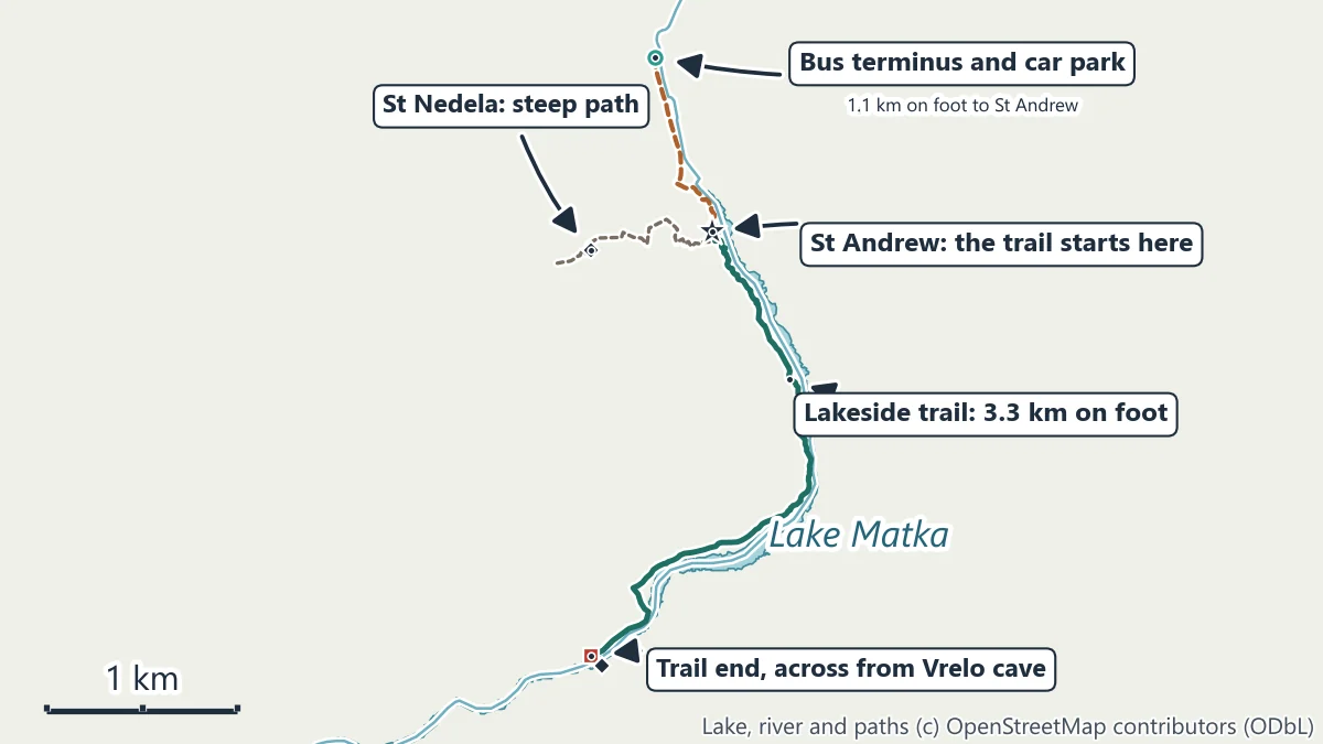
- The churches by the dam and the bus stop. St Andrew stands by the dam, 1.1 km on foot from the bus 60 terminus along the road and a paved path beside the river, and the Matka monastery is 0.4 km from the terminus. Neither needs the lakeside path. See St Andrew and the monasteries.
- The view up the lake. From the dam and the terrace of St Andrew you look up the green water between the cliffs.
- The exhibition centre in the old power house below the dam opens from April to October, every day except Monday, 10:00 to 15:00.
The ban names the walking and mountain path at Matka without listing every path it covers. Follow the signs on the ground and do not go past a warning sign.
The trail when it is open
| Start | Church of St Andrew, by the dam |
| End | Visok Rid, across the water from Vrelo cave |
| Length | 3.3 km on foot, one way |
| There and back | 6.6 km |
| From the bus 60 terminus to the start | 1.1 km on foot |
| Status, 1 November 2026 | closed since 26 February 2026, until further notice |
Distances are routed along the mapped path network between the points named.
The walk
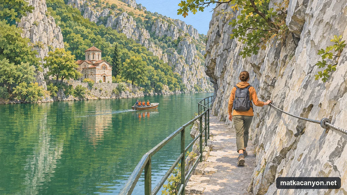
When the path is open, it starts by the church of St Andrew, past the hotel at the dam, and follows the left bank of the lake upstream. It keeps low, between the cliff and the water, on stretches of rock, earth and concrete. Where the cliff closes in, the path narrows to a ledge with a railing on the water side and a steel cable fixed to the rock. After 3.3 km it reaches Visok Rid, a point across the lake from the mouth of Vrelo cave, and stops. You come back the same way.
On 20 October 2023 the City of Skopje began repairs on the path. It announced that it would restore the railings along its length, fix a steel cable to the rock on the narrow sections, mend the damaged surface and replace broken concrete blocks, and repair a second path, from Vrelo cave to Ubava cave. The city has not published when the work was finished.
How hard it is
When it is open, the lakeside path is a walk for anyone used to a few hours on foot. It follows the shore, so there is no long climb, but the surface is uneven and the narrow sections ask for attention rather than effort. The walk there and back is 6.6 km, or 8.8 km from and back to the bus stop. At an easy 4 km an hour, that is about 50 minutes each way from St Andrew.
Steeper paths above the lake
- St Nedela. A steep mountain path climbs from beside St Andrew to the small church of St Nedela high on the slope; the mapped path is about 0.9 km long. It is rough and steep: proper shoes, and not in the wet.
- Holy Saviour and Holy Trinity. Paths on the same slope lead to these two churches above St Andrew.
- St Nicholas Shishevski. On the other bank, a path climbs from the bridge near the Matka monastery to the monastery of St Nicholas on its terrace above the lake: 2.4 km on foot from the bus 60 terminus. See St Andrew and the monasteries.
These paths cross the same limestone cliffs. The notices of February 2026 do not say whether they fall inside the ban; check the signs where each path starts.
Safety
- Keep off the lakeside path while the ban stands. Rock fell onto it in January 2026, and the ban holds until the authorities announce otherwise.
- Obey the warning signs for falling rock on any path at Matka.
- Do not swim from the shore: boats use the lake and the banks are steep rock.
- Leave plants and animals alone and take your rubbish home: Matka is a protected monument of nature.
When the path reopens: wear shoes with grip, carry water for the 6.6 km, hold the railing and the cable on the narrow sections, keep children beside you, and turn back in a storm or if the path is icy.